Here is an inspiring figure in the world of geospatial data science—Rahisha Thottolil, a PhD student at IIIT-Bangalore. Her journey into the realm of spatial data is as fascinating as it is impactful. With a focus on driving action and transformation in urban landscapes, GIS and remote sensing, environmental and natural resource management, and sustainable cities, Rahisha Thottolil shares with Naviiina how she developed a keen interest in this field and how she framed her research topic in understanding the urban growth process.

Discovering the World of Spatial Data
Rahisha’s fascination with spatial data began during her time as a research assistant at NIT Calicut between 2012 and 2014. It was there that she first dipped her toes into the vast ocean of geoscience and landscape mapping. This initial experience sparked a deep interest in how satellite imageries coupled with GIS tools could be used to tackle real-world problems.
Her curiosity led her to pursue an M.Tech in Geoinformatics, where she truly began to grasp the power of analyzing spatial data in real-time. A standout project during this period was her work on coastal zone management in Mangalore. The team developed a shoreline prediction model that was so impressive it earned Rahisha the Young Technologist Award in 2015 from UGIT. This accolade was a testament to her innovative approach and solidified her commitment to geospatial technologies.
The PhD Journey at IIIT-Bangalore
Rahisha’s quest for knowledge didn’t stop there. At IIIT-Bangalore, she expanded her expertise in machine learning, data analysis, and digital image processing. Her PhD research focuses on using advanced geospatial data analysis to understand urban land area expansion, topological pattern of road network, transportation indicators, and model urban growth, with a particular emphasis on Bangalore City. Urbanization is a pressing issue in many Indian cities, and Bangalore is no exception. Rahisha’s research spans 50 years, from 1973 to 2023, analyzing spatio-temporal patterns to uncover trends in urban expansion and predict urban growth in near future. She analyzed the topology of road networks in terms of connectivity and coverage using graph theory. This study investigates the relationship between the connectivity of road networks and the development of the road transport system. It also compares road development across different wards in Bangalore City.
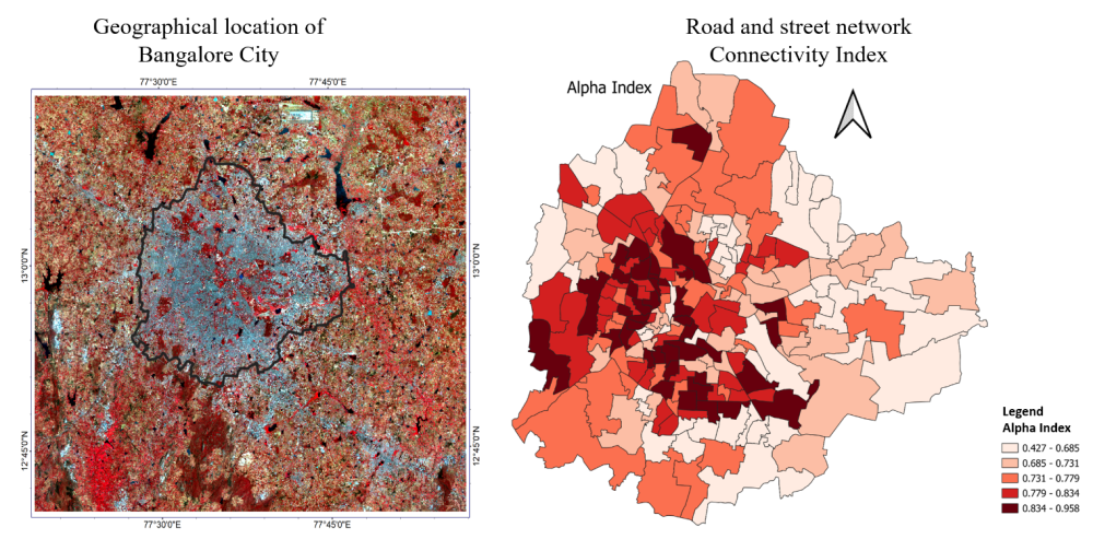
Variation of connectivity measure (𝛼 index) at ward level.
Her findings revealed some startling truths: unplanned growth extending beyond city boundaries and rapid expansion in the northern parts of Bangalore. This research is crucial for developing strategies to manage urban growth and address the environmental and social challenges that come with it.
Cutting-Edge Skills and Innovations
One of Rahisha’s most notable achievements is her development of RidgeGAN—a two-step hybrid framework designed to predict transportation network density in real and simulated cities. This innovative model has been used to evaluate infrastructure needs in various cities, including Mysore, Mangalore, Hubli, Belgaum, and Gulbarga. The model’s application underscores Rahisha’s skill in leveraging Earth Observation (EO) big data and advanced machine learning (ML) and deep learning (DL) techniques.
She makes use of tools like Google Earth Engine (GEE) and applies models such as Random Forest, Ridge Regression, Support Vector Machines, Convolutional Neural Networks, and Generative Adversarial Networks (GANs) to tasks like image classification and prediction. This technical prowess is not just about crunching numbers but about translating complex data into actionable insights for sustainable urban planning.
Overcoming Challenges
Transitioning into the field of geospatial data science from a non-computer science background was not without its challenges for Rahisha. She initially struggled with the technical jargon and methodologies required for her research. However, the supportive environment at IIIT-Bangalore played a pivotal role in her journey.
Rahisha credits her supervisor, Prof. Uttam Kumar, with providing constant inspiration and motivation. Mentors like Prof. Jaya Sreevalsan Nair, Prof. Ramesh Kestur, and Dr. Tanujit Chakraborty (Ex-Mphasis Fellow at Spatial Computing Lab, Currently-Associate Professor at Sorbonne University and Sorbonne Center for AI) also offered invaluable guidance and encouragement. The interdisciplinary nature of IIIT-B’s research community, especially colleagues like Dhanya Eledath, proved incredibly helpful in breaking down complex concepts and providing support throughout her academic and research endeavors.
Societal Impact and Future Aspirations
Balancing her societal commitments with personal aspirations is something Rahisha values deeply. Her research is not just about academic success but also about making a positive impact on urban planning, environmental management, and transportation infrastructure. By aligning her work with societal benefits, she ensures that her contributions extend beyond the confines of academia.
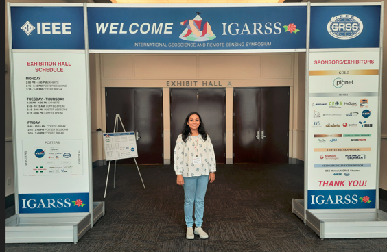
Rahisha serves as the Regional Chapter Coordinator for India in the IEEE GRSS community. She volunteered at IGARSS 2023 and organized InGARSS 2023. Additionally, she chaired the Women in Engineering and DIE sessions during InGARSS 2023, among other contributions.
Rahisha is committed to continuous learning and collaboration with researchers, city planners, policymakers, and community organizations. She understands that solving real-world problems requires a collective effort and is dedicated to maintaining a work-life balance that includes time for personal hobbies, family, and self-care.
Looking ahead, Rahisha aspires to lead groundbreaking research that addresses environmental and urban challenges through geospatial technologies and big data analytics. Her goals include developing predictive models to aid in sustainable urban development, climate change mitigation, and natural resource management. She aims to publish high-impact papers in top geoscience journals and present her work at major conferences like AGU and ISPRS Congress.
In the long term, Rahisha envisions becoming a thought leader in geoscience, contributing to advancements in the field and fostering impactful research collaborations. Her ultimate goal is to create solutions that promote sustainable development and improve community life on a global scale.
Rahisha Maps Future in Geospatial Data Science
Rahisha’s journey through the world of geospatial data science is a remarkable example of how passion and dedication can drive significant advancements. From her early days at NIT Calicut to her current research at IIIT-Bangalore, she has shown a relentless commitment to leveraging spatial data for the greater good. Her innovative approaches, coupled with her societal focus, make her a standout figure in the geoscience community.
Stay tuned for more updates on Rahisha’s work and the incredible impact she is making in the field of geospatial technologies!